I woke up in a motel room in Sioux City, Iowa on the day after Labor Day. I'd been on the road, bicycling, for nine days. The individual days of the week and their calendar dates were lost on me. Other than having trouble finding dinner the night before it had just been another day of pedaling from one point to another. Riding across the central plains of the US is not so much a journey to be taken by and explored as it is a matter of getting somewhere. A ride of destination rather than exploration.
This day's ride contained, in capsule form, many of the elements that can be encountered on an extended bicycle journey. There was rain, sunshine, wind pushing me, and wind stifling me. I was treated by various people as anything from a courageous traveler to an object of mockery. I rode on flat ground and rolling hills, within the heavy bustling traffic of a big city and in open countryside.
Not being much of a morning person, I arose slowly, packed my belongings, fastened them to the bike -- an act that I had converted to ritual -- picked up a state map at the Chamber of Commerce, and was on the road by ten in the morning. I rubbed shoulders with the city traffic, most of it commercial trucks, as I traveled northwest on highway US 75 bound for Le Mars, Iowa.
My final destination was either Sibley, Iowa, or if I pushed harder, my preference, Worthington MN. Sibley was 78 miles away and Worthington over 90. After leaving Sioux City at ten, making it to Worthington was going to require something extra. That morning mother nature, for her own reasons, provided the something extra I needed -- a tailwind.
The day was off to a fine start. There was a safe, adequate shoulder, except for the small construction zones, and best of all, the blessing of a tailwind that buffeted me along for an average of 17 miles an hour. I hadn't had any real breakfast. Some orange juice, milk, and a banana that I'd bought the night before propelled me to a small convenience store where, unable to find bananas or other fruit, my fuel of choice, I treated my sweet tooth to a candy bar.
Twenty-six miles, the distance to Le Mars, seemed like a good distance to ride before getting some real food for lunch. I wanted to save money, so I was looking for a grocery store with fresh fruit and some milk. I had bread and peanut butter with me. A peanut butter and jelly sandwich with a banana and a carton of milk makes a fine lunch.
A long ascending curve led me into the town of Le Mars. I was looking down side streets for a grocery store. I couldn't see one. I even took a diversion, but ended up in a grocery-free industrial zone. As happened many times on this trip, I was unable to spot anything convenient, so I kept going, figuring that the next town would have what I was looking for.
At the north end of Le Mars, I came across the intersection with Iowa State Highway 60, the road I would be on for the rest of the day. The next town was Seney, four miles away. There was nothing there but a couple of big silos. Alton was twelve miles further.
The sky was becoming unsettled. In the morning there had been high cirrus clouds coming from the west, by this time, noon, there were large, low cumulus clouds all around. The temperature was about 60 degrees. The tint of my sunglasses made the sky appear dark enough to give the depressing illusion that rain was imminent, so I took them off.
The road was flat enough that I was able to relieve myself by waiting until I could see no traffic ahead or behind. During the first week of my trip I had learned to drink enough water. I drank a large water bottle (~1 1/2 pints) every hour to hour and a half. When you drink enough water you have to relieve yourself every couple of hours as well. On flat open country roads I didn't even need to find a bush.
There was no shoulder on this stretch of road and it appeared to be a popular truck route. The truck drivers in Iowa, as in Nebraska, were all patient about passing me carefully. If no one was coming the other way, they would signal left and then steer into the left lane to pass me. If another vehicle was coming the opposite way they would slow down and wait until it was clear before passing me. What a difference from the logging trucks on the west coast.
At one point, looking ahead, I saw a large semi-trailer truck approaching me. As always, I looked in my mirror to see if there would be a conflict from behind. There was. Another large semi was coming up behind me and all three of us were going to pass at the same spot. These guys had been so courteous to me all day that, as I saw and heard the rearward truck downshift, I pulled off the road and into the grass and gravel so that all three of us could pass with no more delay.
A couple of miles later, the shoulder became too soft for me to safely execute this maneuver at high speed. No matter, though, since no trucks forced me to. They were unexpectedly, and pleasingly, courteous all day.
As I approached Alton the sky began to leak and I was struck by a few rain drops. As it became a very light drizzle I could see the town of Alton about a mile ahead, up a series of ascending rollers. Since I hadn't made myself rain ready, I raced the weather to Alton. I'd been ascending shallow rolling hills since turning on to 60, and the steepest of them, thus far, were right here. Huff and puff. Please God, let me make it this one more mile without a downpour.
At the south end of Alton there was a cafe and a short, steep hill, beyond which lay the rest of the town. I'd beaten the rain. It was barely drizzling, so I eased up the hill and down into town. Nothing there for me, so I reversed my course and headed back to the cafe. There was a small patio where I parked and made ready for the rain. I put pannier covers on and put my camping gear into garbage bags. The camping gear was fastened with bungee cords and I slipped my rain jacket under one of them. My coat is made of rubber coated nylon, the kind that traps a lot of heat, so I hate wearing it until necessary.
It was 1:00 and I had traveled 42 miles. My average rolling speed had been 16.7 miles per hour. It looked like Worthington, my 90-some mile goal, was within easy reach. I was still hoping to save money by fixing my own lunch, but I also needed to eat. I went into the cafe and asked if there was a store with fresh produce in Alton. The answer was "no, but there's one in Hospers (eight miles ahead)." I ordered some fries and a cherry coke.
As was usual, I was approached by people asking me where I was going and where I'd started. They were astounded by what I was doing and gave me praise for my personal courage and strength. I met a truck driver there and thanked him for the general courteousness I'd encountered. In fact, I told him that I'd appreciate it if the trucks passed a little closer. There isn't much of a draft to pick up on when trucks pass in the left lane. I wouldn't mind them passing a bit closer.
"Not when it starts raining, you won't," he said. Prophesy.
I encountered another person worth talking about in this cafe. The middle-aged woman working behind the counter. She provided the perfect example of a non-cyclist trying to give route advice. She hoped to provide me with an easier route to the next town, Hospers.
On my state map, the official Iowa Transportation Map, Hospers was eight miles north-northeast of Alton. The highway went northeast for about five miles and then curved north for three more miles. Almost a perfect diagonal. She began drawing a map for me that started by going a mile or two east, then left at a stop sign, past some "industry," as she put it, where her husband worked, and then along a county road to Hospers. She would have me take this detour because it seemed faster in a car and I would avoid the viaduct at the north end of town.
I've been misled by advice like this before, so I kindly accepted it, but still rode straight down highway 60 to Hospers. There was no way that this other route could actually be a short cut. She must have been worried about my being on the highway with all those trucks and climbing over that huge viaduct.
As a rule: beware of non-cyclist's advice. Try to get directions from more than one source.
The fries and coke satiated my energy needs and I was raring to get back into that buffeting tailwind. After crossing over the highway viaduct north of Alton, I noticed the road was wet, but it was not raining. My food stop in Alton had serendipitously saved me from a small downpour. As I looked north, against distant dark clouds, I saw strokes of lightning too far away to be heard. I was going that way, but it was no problem. I was rain ready.
Approaching Hospers, the rain began falling and the wind started turning around. I noticed my shoes were beginning to get wet, so I put on my rain jacket and slipped gallon size zip-loc (tm) bags over my shoes. The rain was short lived, but the wind was beginning to become a real bother.
I stopped in Hospers and picked up some bananas, ate one, and stashed the other. Noticing that I was in short sleeves and carrying my rain jacket, the grandmother at the grocery shop warned me that this was prime weather for catching a cold. (I kept my mouth shut, as I know that colds don't come from bad weather, rather from physiological depression, which I was definitely not suffering from.)
Leaving Hospers, the sun came out. It seemed I was following a hole in the clouds and would have fair weather with me if I kept following the correct spiritual pace. I must have missed it. The wind began blasting at me. It was difficult to keep my pace over nine or ten miles an hour.
I wished that the wind would turn around. I would accept and even prayed for a downpour to accompany it. Just get that wind out of my face. A headwind can ruin anything. Be ye in paradise, 'twould seem like hell, were there a headwind.
I crept sixteen more miles to Sheldon, a big town. Big enough to have stop lights and big ruts in the road. And all the while a constant stream of cars passing by. Damn wind!
I finally left Sheldon. I'd been noticing that since I turned onto state highway 60, 16 miles south of Alton, I'd been on ascending rollers -- rolling hills -- anywhere from 30 to 100 feet each. You see the crest in the distance, climb to the top, and it just levels off. There's no downhill on the other side to coast on. This was verified by my altimeter (Avocet 50). I was climbing. That and the oppressive headwind were breaking my spirit. Maybe I would get a cold.
[I noticed later, on my map, that the highest point in Iowa is three to four miles north of Sibley -- 1,670'.]
With the northerly headwind blasting in my ears I looked down at my speedometer. "Shit, I'm only going 8.5 miles per hour. Focus! Put more meat in it. Chew the big one. Grind. How much further to the next town? Don't look. Wait longer. Damn, here comes another truck! Even more wind. 6.5 mph. Chew on it. Get your speed back up (to 10 mph). How much further. OK, look. Not even another mile. How come all the trucks are coming at me. I hate this wind! Acchhh! Here comes another truck."
Ten miles later I was in Ashton. There was a neighborly little rest stop by the roadside. A picnic bench in the grass by a big tree. Beginning to feel the nutrition depletion bonk, I decided to lunch there. I loosened my bungee cords and dug bread, peanut butter, and a banana out of the day pack that was strapped on top of everything else.
Zzzzzzzzzztt. Slap! Get out the bread. Zzzzzzttt. Slap! Where's that darn knife? Zzzzzztt, zzzzzztt. Slap! Slap! I'd stirred up a bunch of mosquitoes from the tall grass I was standing in. I piled my lunch on top of my packs and started walking across to a nearby gas station. That's when my camping gear and daypack flopped off the back of the bike and the loose bungee cords grabbed for anything -- the spokes, the hub. I dropped my lunch, refastened the camping gear and scooted over to the nearby gas station. I went back, picked up my lunch, and tried to eat it outside the gas station. Flies. Farm country and flies. Too many to tolerate, so I ducked inside the gas station and asked if I could "picnic" in there. Thanks.
After a quick lunch, constantly swinging at files, I hit the road again. The weather had been shifting around all day. And now, great luck. I could hardly believe it. The wind was actually at my back. Ya hoo! My impatient determination had made me put off stopping to eat lunch. Now, it was as though the gods were rewarding me for stopping and taking the time to eat.
I flew into Sibley. My average speed had dropped from nearly 17 mph to 14 mph. On the way to Sibley, in just seven miles, I got it back up over 15. About a mile outside of Sibley, I became aware of a car behind me and then something hitting my back. I looked up and saw scrawny "Beavis and Butthead-like" arms hanging out of the window of a small, passing, silver sedan. And I, without thinking, gave this motley teenage crew the angry, profanity-spewing show that they had been hoping to invoke. The little shits. I wanted to tear one of those arms off.
Agghh. I wish I hadn't reacted at all. There was no pain and no mark. Who knows what they hit me with.
[This was the only incident of this nature on my entire trip -- the only bad feelings shown towards me by anyone.]
Now, my earlier prayer was answered in it's entirety. Just as I was entering Sibley, the sky opened up and the rain began to pour down. I dashed under a gas station roof and put on my rain jacket and zip-locs. I'd asked for it, but it was alright. I was right. Rain is no problem. Headwinds are. If it takes rain to stop a headwind, bring it on.
Oh yes. As the truck driver in Alton had said, the spray from passing trucks was not desirous. It was exhilarating ... but also blinding. I learned to wear my sunglasses on my forehead so that I could quickly drop them down over my eyes when a truck passed.
The rain only lasted a few miles and the winds died down, too. As I crossed the border into Minnesota I removed my rain jacket and shoe bags, which by the way, were holding out fine. Happiness came over me as it did at all major benchmarks on my trip. I even got a little delusional. I thought the Deer License sign outside of a gas station rest stop said Beer License. Did I really need one of those in Minnesota?
Worthington was an easy ten miles after the border. I was in high spirits. When I passed 90 miles I said to myself, "I'm in century land." I'd easily be doing over 95 miles and, being fully loaded, I felt it qualified as a true century. The RAIN corner century. How appropriate.
Actually, I'd thought of the acronym as I was trying to kill time, riding between Alton (the cafe at 42 miles) and the Minnesota border. The concept came pretty easily. It had been a rather full day as far as riding conditions go. And I'd sheared off the northwest corner of Iowa in a single, one-hundred mile day.
I stopped at a gas station in Worthington and got advice from a pair of high school-aged, midwest farmer's daughters. "Why did you come to Worthington? There's nothing here." (It's actually the Nobles County seat, with a population of 10,000 -- bigger than most towns I'd seen since I left Colorado.) They told me where the motels were and then, for some odd reason, wanted to see what a Colorado driver's license looked like. I obliged and then moved on.
Just as I had done the night before, I found a local, independently owned motel (the best kind). And, coincidentally, it was run by a middle eastern fellow that I unintentionally ended up haggling over price with. After looking at the room and telling him that I wanted to look at a couple of others motels before deciding, the bartering began. He said that if I had a car he would offer me a lower price.
"..... What?"
"You mean, if I wasn't on a bicycle, if I drove a car, you'd offer me a better deal?" I was pissed, but biting my tongue, and hoping for a reasonable explanation. Maybe I hadn't heard him right.
"That's right," he said. Then he explained. If I was in a car and I went to look at the other room I'd come back, but since I was on a bicycle, I might not be inclined to ride all the way back. Hence, why bother to offer a price reduction. I guess I understood. It was not my kind of logic, but it was obviously not ill intent on his part. Just his style of business. He turned out be a very nice person. I liked him.
"I'm still going to go look though."
"I know where you will look and it is not better. You will see. This is a finer room."
We both knew where I'd be looking. In fact, I'd already been there and I did like his room better, but it cost $2 more ($24). Anyway, my real mission was to find a motel that was convenient to beer and groceries. He thought all beer in Minnesota was the same, but I told him I'd find out for myself. As I began to ride away he followed with, "$22, you can have room for $22."
"Ok, I'll probably be back shortly."
Two kind ladies at the Phillips gas station informed me that convenience store beer was only 3.2 beer. The only real beer was at the liquor store at this end of town, another mile back into the headwind and two miles from the previous motel. They also told me about a lounge nearby with a good menu that was developed by a friend of theirs who now lives in Colorado. Coincidence seems, sometimes, to be a divine message. Like a road sign for the spiritually aware. Everything was in place.
I came back, got the room, got some beer, and went out to the lounge the ladies had suggested (it's in the Northland Mall) where I had fettucini alfredo with sauteed chicken breast. The food was excellent, the company, well, not boring. One college age kid at the bar was from Mankato, my destination for the following day. He had lots of route advice and information . . . for whatever it was worth.
Total distance from the Imperial Motel in Sioux City IA to the Shady Lane Motel in Worthington MN (10:00 A.M. to 6:00 P.M.) - 95.4 miles. Total climb - 1050'
Ave. speed (rolling) - 15.1 mph
95 miles in 8 hours -- a good pace for me. Total Miles in 10 days - 734
The Platte River Valley -- Part I
My original plan for riding to Minneapolis was to ride from my home in Boulder, northeast, towards Nebraska. Then meet up with the old state highway that parallels US interstate 76 and follow it to North Platte, Nebraska (about 300 miles). From there, I figured on riding north into the unknown terrain and towns of central and northern Nebraska.
I rode form Boulder to Greeley Colorado on my first day, to Sterling on the second, Julesburg on the third, and finally, North Platte Nebraska on the fourth. In North Platte I changed my plans about riding north into Nebraska and decided to follow the Platte River Valley, east.
The decision to follow the Platte River Valley, which is also the Oregon, Mormon, and Pony Express Trails, started taking shape in my mind on the second day of my ride.
I started my trek on Sunday, August 29th. I got a very late start. How late, I'm even embarrassed to say. Yet, following a route I'd taken before to Loveland and then Greeley, I still rode 60 miles. It was just after sunset when I located a commercial campground in the Greeley phone book.
It was a fine campsite, except for the $13 fee. That bought me a flat, grassy spot with my own picnic table, use of the clean shower room, toilet, and a laundromat.
As I was setting my tent up, in the dark, a cold front moved in. The temperature began dropping and it got very windy. There was enough wind that, as I was trying to set up my tent, it kept blowing the groundcloth away. Then the tent. Then the groundcloth, again. And, oddly, there were mosquitoes -- lots of them. The wind wasn't chasing them away. There were still enough of those miserable bloodsuckers that I had to use repellent so I could quit slapping myself and finish erecting my Eureka (two-man tent - the Tadpole design).
When that was done I rode a mile back to a convenience store and bought a six pack of beer. Once back at camp, I cooked my dinner -- southwestern style, dehydrated red beans and rice -- which I consumed with a few chunks of bread from a loaf of sourdough. I squeezed margarine onto each slice. This was an original idea I'd had just before leaving. I used a squeeze tube to carry my margarine. This worked well to efficiently dispense margarine without any mess.
I noticed some slight knee pain that night, but I always have that.
I decided I'd take it easy on myself and take the whole next day to
cover 60 miles.
"The best laid plans ..."
I awoke on Monday morning, had an instant breakfast made with powdered milk, and some instant oatmeal. Goop. I used the laundromat to dry the clothes I'd washed the night before in the shower, as it had rained a bit during the night and, since they were hanging outside, they were still very wet. I was away by 10:00.
Things were going fine. Greeley is cattle country and I'd never seen all the stock yards out there from so close up. The ranchers make a pile of dirt and manure about six feet high within the pens, and there's always one cow, smarter than the rest, who decides to climb the pile, as though to take a position of superiority over the rest of the herd. It was this one cow, in each yard, that I'd make eye contact with and wave to. I depended on him to pass my greeting along to the others.
Poor cows. I wonder if they have any sense of what the future holds for them. Of how meaningless and futile their existence is. Where the hell do cows come from, anyway? I can't imagine them living in the wild. "Oh look over there. It's a herd of wild cows."
I was following a very pleasant back route I'd selected from my official state bicycling map, "Bicycling Colorado". The roads marked green are preferable, yellow less so, and the red ones are unsuitable, as all of the state bicycling maps I encountered labeled them.
While planning my route I had noticed a small church located about 90 miles from my house. Before leaving I'd entertained the notion of camping there, but due to my very late start was unable to get that far. Good thing.
About 15 miles out of Greeley there is a small road, marked green, that covers the 18 miles between Barnesville and Briggsdale, connecting state highways 392 and 14. After nine miles of riding on this peaceful, solitary, paved country road, the surface became soft dirt up to two inches deep. I rode as much as I could, but was forced to stop and push my bike in many places. Needless to say, the additional strain needed to stabilize the bike and keep driving forward, at only 5 or 6 miles an hour, was not part of my "best laid plan" on this easy day.
A mile or two into this stretch of road I came upon a road crew. As I approached, one of them came towards me and asked if I was low on oil. Puzzled, but somehow understanding, I just chuckled nervously. I asked how much further these road conditions continued and he said I only had seven more miles to go.
I felt anger toward this road crew, assuming it was their fault for putting all of this fresh dirt on the road. "Are you resurfacing the road? How much further does this fresh dirt last?"
"This road has never been oiled," another one of the crew replied. (Hence, the "low on oil" comment.)
"You guys won't believe this one, but on my Colorado bicycling map this route is marked green, most favorable."
"Someone really screwed up, didn't they. Maybe you ought to straighten them out. Hee haw"
"Yeah. Thanks. Bye."
"You've only got seven more miles to go."
Seven more miles. Shortly after continuing on, semi-trailer trucks started coming towards me from the opposite direction. As is usual, the left side of the road seemed to have the best surface. I rode to the left side most of the way, that is, until one of those trucks would come along. It was easy to see them coming. Whew, what a dust storm. I think this was a short cut for truckers trying to avoid the weigh stations along the interstate.
I noticed the little church about halfway through the dirt section on the road to highway 14. It was just a little one room wooden church about 100 yards off the road. I was glad that I hadn't tried to make it there last night. It was a fine spot, but getting there would have been a real hassle, especially late in the day
A mile or so later, on this dusty route, hunger pangs arose from within my empty stomach, and I stopped to have some peanut butter and bread with water. Stopping to rest, I became aware of my surroundings and realized that I was in a very pretty, quiet spot. Raptors were soaring overhead. Old cottonwood trees reached up from the creek beds above smooth, yellow, grassy hills that rolled off in all directions to the distant, deep blue sky.
When I saw the little farm community of Briggsdale and finally emerged onto highway 14, I was greatly relieved to have hard tarmac under me again. I passed a diesel fuel station on my left and noticed a couple of bicycles parked outside that were loaded for touring. Unaware that these were the only other bicycle tourists I'd see in the next two weeks, I just kept going. I was hoping to find a restaurant or cafe, and soon.
After ten miles or so of climbing, riding up and over shallow hills, I reached a spot that looked like high ground. My map said that I would be going over the south edge of Seven Cross Hill, so when I saw a radio antenna reaching into the sky, I figured I was at the crest. Feeling like I was ready to bonk, I stopped, leaned my bike against a speed limit sign, and sat on the brittle, dried out grass. I had a chocolate instant breakfast (made with tepid water and instant milk) and more peanut butter on sourdough bread. A warm, plain, dry lunch. It was almost unpalatable. I felt like shit. It was hard going since that nine miles of dirt had sapped my strength and patience. I just sat there with my dry peanut butter sandwich, warm instant milk, the heat, dry grass, and a variety of bugs; mostly grasshoppers.
Just then, two cyclists rolled up and we started talking. It was the pair from the diesel station several miles back. Having just gulped down the last of my meager road rations, I joined them and we rode together for the next 20 miles.
Mike and Ruth, a married couple from Connecticut, had started their trip that very morning in Ft. Collins and had been riding all day on highway 14. They were riding across the country in intervals. A couple of years ago they'd ridden from the west coast to Cheyenne, Wyoming. This year they were riding from Ft. Collins, Colorado to Manhattan, Kansas. Their companionship erased all of my blues and I was a happy saddle jockey again.
My map of Colorado had a picture of a little evergreen tree floating just above the town of Raymer. That meant a campsite of some kind. Raymer was 58 miles from my starting point in Greeley and a good place to for me to stop on what was now this not-so-easy day.
We rode east, past the scenic Pawnee National Grasslands and Buttes, which were to the north. We chatted and slowly churned out the next 20 miles. The pace was slower than if I was alone, but I felt great -- reinvigorated.
In Raymer, there was a little cafe by the side of the road. Mike had eaten a microwave burrito at the diesel station, and he and Ruth were ready for something a little better. I was famished and looking forward to a real, tasty, sitdown meal.
It was a fine little cafe. There were oil paintings of the local scenery on the walls that were obviously the work of a Raymer artist. Milkshakes all around. I had the grilled chicken breast sandwich and fries. The food was delicious, but the information I received was bothersome.
"Yeah, every once in a while someone asks me about that camp ground," said our waitress/cook/hostess, "and I tell them the same thing. I've lived here all my life and there has never been a camp site near here. I don't know why it's on the map."
Sterling, the next real town, was another 32 miles down the road. It was after 5:45 and there was hardly enough time to make it there in daylight. Besides, I really did not want to ride 32 more miles and put all that extra wear and tear on my old knees. I was hoping I'd see some kind of campground before riding all the way to Sterling.
Two miles after Raymer, Mike and Ruth headed south on highway 52 to Ft. Morgan, where they had a motel reservation. They had 25 more miles to go and I had 32; if I had to go all the way to Sterling. I began entertaining the thought of getting a motel room in Sterling. If I was going to have to ride after sunset, 30 more miles than I had expected, especially after the grind of those nine miles of dirt, a motel room sounded like a good idea. I had bounced my motel musings off of Mike and Ruth for the last two miles before we parted ways.
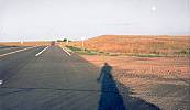 The sky was clear, and as the sun was setting behind me, a full moon
rose ahead of me. My elongated shadow extended some 30 feet ahead in
the soft, warm light at the end of day. I followed my shadow towards
Sterling. I hadn't see any other place to stay on the way, and when
I arrived in Sterling, after dark, with my rear Vista-lite
flashing, it was 8:30 P.M. I was exhausted. The last 30 miles had
been won by perseverance and a trick I learned while riding rolling
hills.
The sky was clear, and as the sun was setting behind me, a full moon
rose ahead of me. My elongated shadow extended some 30 feet ahead in
the soft, warm light at the end of day. I followed my shadow towards
Sterling. I hadn't see any other place to stay on the way, and when
I arrived in Sterling, after dark, with my rear Vista-lite
flashing, it was 8:30 P.M. I was exhausted. The last 30 miles had
been won by perseverance and a trick I learned while riding rolling
hills.
Looking ahead, you can set short, intermediate, and long term goals. The next hill, usually less than a mile away, short term; some number of hills beyond it, intermediate; and finally, the horizon or highest point in the distance, long term -- anywhere from a couple to five miles ahead. Eating up the short term goals breaks the long term goals into easily digestible pieces.
Beyond one of those far away hills lay the Platte River valley and I'd be heading downhill the rest of the way into Sterling. As usual, that point was a lot further along that I wanted it to be. I got there about dark, half way through twilight, turned on my strobing tail light, and coasted into Sterling Colorado.
After asking for directions at a convenience store, the unofficial tourist information center, I found the local strip of motels, and a room for just $21.75 plus tax.
There was some interesting confusion when I asked the clerk if I could bring my bike into the room. She told me that I could leave it right outside the door. I asked if this was the kind of town where I'd have to lock it up. She replied, "this town is small enough that if someone takes it, everyone will know who did and where they took it."
"Well, I'll just lock it to something with my cable. Where I come from bicycles get stolen all the time."
"A bicycle? You pedaled here from Greeley? Today? You're going to pedal all the way to Minneapolis? Why in the world are you doing that?"
I hadn't developed a simple answer for that question, yet, although later it occurred to me to tell people that it was a vision quest.
"I thought you wanted to bring your Harley motorcycle into the room with you," she laughingly acknowledged.
This was the first of many misunderstandings I would have with people that assumed I was riding a motor bike. It's important to use the word bicycle instead of bike when describing your venture.
I unpacked, rode back out for a few beers, a big turkey sandwich, fresh fruit, orange juice and milk, and came back to my room. I iced my knees and began my regimen of taking 800 mg.s of Ibuprofen, four times a day. I even got to watch the premier of the David Letterman show on CBS. He really cracked me up. I didn't feel so alone anymore. I had a buddy.
There was a faint smell of insecticide in the room and the mattress was soft. These were probably the worst accommodations I had on the entire trip, but still, this motel room was easy, efficient, and restful.
90.7 miles from 10:00 - 8:30
ave speed - 11.3 mph
1250 feet of climbing
Copyright (C) 1993 by C. Anderson - All Rights Reserved